APRS of Automated Positioning Reporting System
Introduction
APRS was invented and developed by Bob Bruninga, WB4APR. Any hamstation that runs APRS transmits a beacon with its position data. Even when a station is portable or mobile, it can combine a GPS with their hamradio, making it possible to track it. Although APRS was originally designed for positioning, it was extended for sending messages (sends automatically your callsign and receives an acknowledgement), weather data, etc... All data transfer is via packets at 1200 baud in UNPROTO mode (UNPROTO means non-addressed). These packets are received by digipeaters and re-transmitted making it possible to 'see' stations at large distances. You can even go online to watch APRS traffic all over the world ...
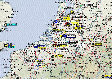
The picture on the left is a typical screen you will get after only a few minutes of receiving APRS signals (click to enlarge).
One of the big advantages of APRS at home is the minimum on equipment it requires. Most amateurs, even those with only limited sources, have it in their shack ... So what do you need then ? A transceiver for 2 meter/70 cm, a PC with soundcard, and the cables to connect them, that's all it takes. The software is freeware and is provided below.
How to get APRS into your shack ?
In what follows the method for using soundcard is discussed entirely. It was kept as clearly and condensed as possible, in order to make hams ready for APRS in about half an hour ...
Of course, you will have to get the right software. I assume you already downloaded and installed AGWPE. If not, you can find it in the Digimodes section of this website under 'Windows settings and software'.
Next, you need an APRS program, for which i use UI-VIEW (screendump: see above). UI-VIEW was written by Roger Barker, G4IDE, and is the program you need to do APRS. It also supports TNC in KISS Mode and BPQ Host mode (besides AGWPE host mode). Roger Barker unfortunately went silent key due to cancer in 2004, but his software is still in use all over the world. You can find all information and more software of Roger on http://www.ui-view.net/ (opens a new window) or just read on here.
There are 2 versions: UI-view (16bit) is not intended for Windows XP or newer and is almost fully functional without registration. The only restriction is that some of the IGATE functionality is disabled.
The other version is UI-View32 which needs a 32-bit version of Windows. It even works fine under Windows Vista, Windows 7 and Windows 8 but because of UAC (user access control) it should not be installed below Program Files. UI-view32 needs registration to work. You have to make a donation to a cancer research organisation. The most easy way for registrating is to follow this link: http://www.apritch.myby.co.uk/uiv32.htm (opens in a new window). Believe me, it is worth it since you will get a great piece of software!
download UI-view v2.39 (16-bit version) or UI-view v2.03 (32-bit version)
Now, follow the next steps to make UI-View work properly with AGWPE.
1. Run AGWPE first and then start UI-VIEW. Select 'Setup' on the top toolbar and choose for 'Comms Setup'. Just be sure you have 'NONE' for 'handshaking' and select 'AGWPE' in the 'Host Mode'. Press the 'Setup' button next to this selection.
2. In the resulting AGWPE Setup window, choose for 'mode' and then select TCP/IP.
3. Press the 'OK' button in both the AGWPE setup window and the Comms Setupwindow.
4. Go to the 'Setup' in UI-view again and choose for 'Station Setup'. Fill in all the fields (callsign, latitude, longitude, beacon comments and the beacon interval time) and click on 'OK'.
5. Choose in the top toolbar of UI-VIEW for 'Maps' and choose for 'Load a Map'. You will get a list of the maps in the directory 'Maps' of UI-VIEW. All maps must have two files : the map itself (in .gif format) and an .inf file. In the .inf file you will find the borders of the map (latitude and longitude) and the name of the map that will be displayed in the 'Load a Map' option. You can make your own maps to be used, but lots of ham operators have done this for you, and it would be very exeptionnal if your area wasn't mapped already.
Your done! Turn your transceiver to the frequency used in your region. You should now be receiving and sending APRS packets. Most of the European countries use 144.800 MHz, but some countries also use other frequencies in the 6 meter, 70 cm and 20 meter bands. APRS can nowadays even be found on some satellites and on the International Space Station (ISS) where there is a APRS digipeater (downlink 145.800 Mhz, uplink 145.990 MHz and digipeat via NOCALL)! In North-America the APRS frequency on VHF is mainly 144.390 MHz.